BASQUES ABROAD.
There is substantial evidence of ancient Caucasian Basques crossing the Atlantic from Spain and France to the Eastern Seaboard of North America from about 8,000-years ago. The Algonquain Indian language of North America, extending to the Great Lakes region and almost across the entire continent has many clearly identifiable ancient Basque words.
"There is a relationship between the Algonkin and the Basque languages. In my opinion it is an old relationship, stemming from before the times of the coming of the Indo-European language to south and western Europe, as evidenced by the nature and form of these tongues, the demonstration of which is the topic of this article. These tongues are not readily understandable by "Latin Grammar", speech-part classifications due to their "agglutinative" syllabic-word string nature, and the syllable-word forms which convey meaning via geometric-shape concepts attached to particular word-family systems of sounds, which the following investigative examples begin to show. (See: Migration and Diffusion, by Paula Baker Sten, Volume 1 / Issue 03, July-September 2000).
"Specific links include words for elbow, foot, head, breast, shoulder, guts, lake, river, louse, birch bark, ocean, boat, snow (falling), snow (on ground)" (See Dr. Merritt Ruhlen, Proceedings of the National Academy of Sciences).
The fact that a very high percentage North American Indians carry the European "Y" chromosome or other ancient European genetic material, coupled with the oral tradition histories of the tribes themselves, attests to the fact that there was a long-established Caucasian presence in North America before the epoch of the "Native American" Indian populations. The oldest skeletons found in North America are Caucasoid (including that of Kennewick Man"). In Peru, Mexico, Bolivia and other South American countries tens of thousands of perfectly preserved Caucasian mummies have been unearthed, but chronic Political Correctness policies, adopted and religiously enforced within the academic establishment, keeps this information from the public and out of the history books. To see the South American mummies, CLICK HERE
The same problem of suppression extends to Egypt and its environs, where the oldest mummies found are Caucasian.
Although the isolationist-classicists would have us believe that getting across the Atlantic to North America was nigh on impossible to accomplish, the fact is that one can do the journey and be within sight of land for most of the way. Consider the following.
(1) France to England is 19-miles. (one then sails up the coast to Scotland).
(2) From mainland Scotland and its offshore Orkney Islands group to the Shetland Islands is 47-miles, with an interim small island in between (one then sails around the Shetland Island coast to the western extreme).
(3). Now a big voyage of 178-miles to the Faroe Islands (one might be out of sight of land for a day or so, but hovering clouds over the Faroe's landmass and other indicators, like migrating birds, should point the way). Once there, one sails around the Faroes to the western side.
(4). Now the biggest open-sea leg of the entire journey is to very volcanic Iceland, 260-miles distant. Plumes of smoke rising from the often active volcano's, as well as other indicators, would have helped ancient mariners to visibly locate Iceland. Once there and reprovisioned, one then sails around Iceland to its western side.
(5). Now a journey of 178-miles to Greenland. Again, one sails around the coast to the western side and commences the final leg.
(6). The final stage of the journey is to cross 196-miles of open water to the coast of North America, from whence one can sail for about 9-thousand miles, hugging coastline all the way, to the southern reaches of South America.
The sea lane route west to the Americas across the Atlantic from Europe & Mediterranean countries, or the walking route east through Mongolia & China were used by droves of migrating people from as early as tenth millennium BC.
THE MEASUREMENT STANDARD USED AND SPECIAL NUMBERS BUILT INTO PYRAMIDS FOUND IN CHINA.
Beyond forensically testing human remains or looking for unique cultural identifiers in artefacts, one can test the measurement standard used in the building of ancient structures, when seeking to establish the ethnicities involved.
At some time prior to 6000-years ago or earlier and coming forward to the third millennium BC or so, there was a spate of pyramid and mound building going on worldwide. In each case investigated by this researcher the selfsame measurement standard and encoding of particular, highly factorable numbers, has been the case. The increments used by the ancient builders have remained the standard metrology systems of Caucasian-European nations for thousands of years, right up until modern times.
Let's look at the dimensions of a northeastern Chinese pyramid and seek to identify the encoded meaning of the lengths and angles found thereon.

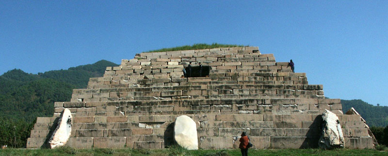
This very impressive stepped stone pyramid is called variously the Gaogouli Pyramid or the Tomb of the General. It is situated to the North of Korea at Ji'an, Jlin, China at coordinates Lat: 41.157650, Long: 126.226400.
This Chinese-Korean Pyramid is officially said to have a square base measurement of 31.58 metres per side. It also has a series of obelisk stones leaning against the base, the tallest of which has been measured at 4.5 metres.X 2.7 metres. The pyramid's square base is offset from the cardinal points of the compass and its eastern side appears to orientate towards north at an intended azimuth angle of 314.16-degrees (coding PI @ 3.1416).
The measurement standard by which it was built is recognisable within the factorable number system and universal measurement standards used by the Caucasian cousin nations since remote antiquity and up until modern times. Consider the following:
1. The base length of 31.58 metres easily converts to 103.68' (10317/25ths) or 1244.16" (12444/25ths).
2. This length is equivalent to 60 of the largest of the Egyptian Royal Cubits @ 1.728' (20.736" ... 2092125ths). Sir William Flinders Petrie identified usage of this particular cubit in his measurement of the coffer in the Khafre Pyramid, wherein it was 5 of these cubits long or 103.68-inches. Note: A cubic foot (12 X 12 X 12 inches) = 1728 cubic inches. Also the base circumference of Silbury Hill in England is 1728', based upon a diameter of 550'.
3. The "Cab" volume,within the Jerusalem liquid volume standard was 103.68 cubic inches.
4. The "Stirling Jug" standard capacity volume of Scotland was 103.68 cubic inches.
SO WHAT IS THIS BASE LENGTH CODING?
It is coding the equatorial size of the Earth and principles related to navigation across the vast, featureless oceans of the world. It is also coding the speed at which the Earth rotates each hour, which leads to an understanding of an accurate chronology system for measuring the daily passage of time. Here's how it works:
1. The ancient way of reckoning and remembering the equatorial size of the Earth was 12 X 12 X 12 X 12 X 1.2-miles or 24883.2-miles. The half value of 24883.2 is 12441.6 or ten times the inch value generated on any one side of this pyramid.
2. If one circumnavigates the pyramid @ 103.68-feet per side , then the distance covered is 414.72' (41418/25ths). If this value were read symbolically as "miles" then that distance would by 1/60th of the equatorial circumference or 6° of arc.
3. With the Earth considered to be 24883.2-miles in circumference its rate of speed in miles per hour is 24883.2 ÷ 24 hours = 1036.8 MPH.
4. The half value of 103.68* is 51.84 (5121/25ths) and the slope angle on the Great Pyramid of Egypt is 51.84° . The Great Pyramid @ 756' long is 72 Hebrew reeds in length. It therefore covers an area of 72 X 72 reeds or 5184. Alternatively, the sum of 51.84-years is 1/500th of the 25920-year duration of the Precession of the Equinoxes.
5. The azimuth angle that the Octagon of Newark Ohio, USA (a very sophisticated and large geometric earthmound complex) lies on is 51.84° .
6. When navigating at sea using the ancient British league of 16500' (3.125-miles of 5280') for linear legs of distance covered, the plotting circle generated per league was 51840'. This plotting circle was then fully divisible by 360° and as long as legs of straight line travel were done in accumulations of full leagues or lesser divisions thereof before a heading change, then accurate calculations related to positions at sea were easily facilitated. By this mathematical method the navigator could always keep track of the angle back to the point of departure or onwards to the destination.
It seems apparent that the height of the base tier of this pyramid was intended to represent 10.368' or 124.416", which again would act as a mnemonic device for remembering the equatorial circumference of the Earth and the speed of its rotation.
As it turns out, every length and angle on this little stone pyramid would have been coded to identify some aspect of the ancient metrology system and the profound sciences of the astronomer-mathematician-navigator builders. Although we could go over every measurable aspect of the edifice to demonstrate this, let's home in on the codes contained within the tallest obelisk leaning against the base tier:
1. Its measured height (4.5 metres) easily converts to 177.1875" (1773/16ths inches). The length of a lunar year is 354.375-days or twice 1773/16ths days. Its width (2.7 metres) easily converts to 8.859375' or 106.3125" (1065/16ths inches). The sum of 1065/16ths days would be 1/64th of the 6804-day lunar nutation cycle. It would also be 1/24th of the 2551.5-day lunar cycle (7.2 lunar years) tracked alongside 7-solar years within the ancient lunisolar Sabbatical Calendar system.
Although these values shown above can look complex and clumsy when rendered as decimal fractions, they are actually very simple fractions under the old integrated imperial standards, used by Caucasoid nations since remote antiquity. To this day American carpenters are still cutting the timber components for their buildings and refining their cuts to 16ths or 32nds of an inch in standard, everyday working practice. Their system of metrology is thousands of years old. and is a small surviving part of a much wider system used by all of the cousin nations to build and maintain their worldwide network of civilisations since time immemorial.
For most Europeans however, the old system was displaced by the forced imposition of the less versatile metric system. Whereas the old system could address every trade or scientific need with simple arithmetic, down to calculable refinements of a thousandth of an inch or greater (precision engineering), metrification is, by comparison, very limited. For example, the old sexagesimal system of chronology (time measurement) had to remain, as metrification could not provide a workable system to replace it.
In truth, the Gaogouli Pyramid of Ji'an, Jlin, China would not be out of place amidst the many stone pyramids of the Yucatan Peninsula of Mexico and would comply to the selfsame measurement and angle codes built into those farflung edifices, or yet others half a world away in the Pacific Basin. So, does this pyramid really date from only 500 AD or so, as claimed, or is it thousands of years older? Was it actually built as a mausoleum for the illustrious dead or was this code-bearing scientific instrument only reduced to that undignified role by ignorant, late era royals with overly-inflated views of their own self-importance? This same question has to be asked about the vast complexes of huge earthern pyramids elsewhere in China.
*Footnote: the 103.68' numerical progression code might also have applied to the height of the second largest of the pyramids of Bosnia, Eastern Europe. It is said to have a height of 190 metres, and if more refined measurements verify this, then the value is very close to 622.08' or 6 X 103.68'.
SO, WHAT WAS THE ANCIENT INTENTION WHEN BUILDING THE PYRAMIDS AT XI'AN?
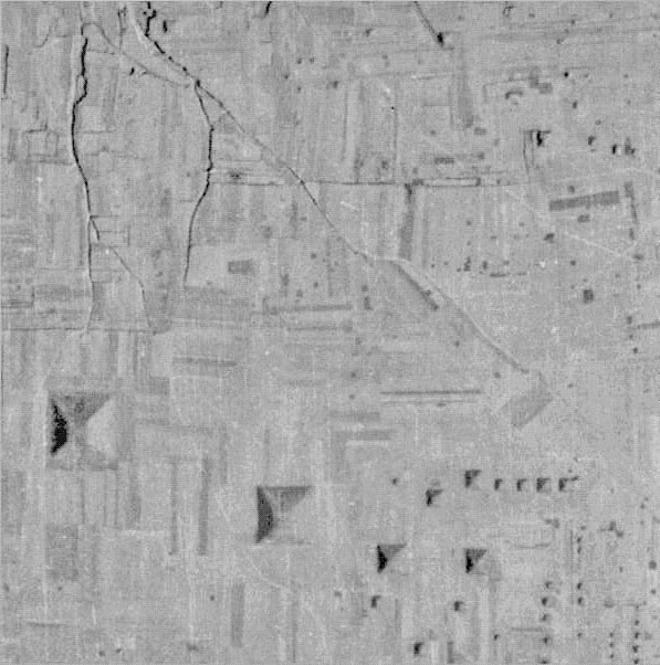
An early spy satellite photo of the XI'an pyramids taken in 1976 shows the pyramid complex very clearly. Quite obviously the photo was taken close to the time of the Equinox and in the morning, as the distinctive shadowing is fully on the western side of the pyramid humps. Sadly, many of the much smaller pyramids, easily seen in this photo, have been totally eradicated by intensive farming activities and are now undetectable in Google Earth imagery. This is especially true of a large cluster in the lower and upper right hand corners of this picture. It's amazing that the ancient structures remained largely intact for thousands of years, only to be demolished and erased in the past thirty years.
By reference to high resolution satellite photos taken in the 1970's or so, we should be able to mark on the recently denuded terrain of XI'an the exact positions of former pyramids, mounds and markers. It will be absolutely vital to do this if we are ever to understand the full design layout of the pyramid complex and intended codes of position envisioned by the original astronomer-surveyor architects.
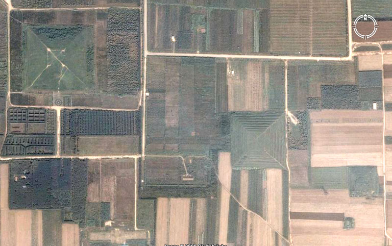
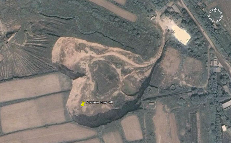
Three of the larger pyramids at Xi'an, Shaanxl, China and at least one smaller one in the set are seen in this Google Earth picture. To the top left is seen the largest pyramid in the region and it acted as the fulcrum or main surveying platform for the positioning of all secondary pyramids or mounds in the vicinity. A high natural promontory outcrop situated 2.5-miles due North obviously provided the exact fix for North from atop this pyramid. Alternatively, seemingly the highest mountain peak (over 2500 metres ... 8200-feet) is situated 15-miles due South. It sits between Zhongnan Mountain and Mount Nanwutai and has superior height to both. It seems likely that the decision of ancient surveyors to place the pyramid in its exact position was due to the fixed position of that mountain peak at 180° azimuth
 .
.
The very visible upthrust hill that stood 2.5-miles due north of the pyramid. A carefully placed marker on this hill would have provided an exact fix for North.
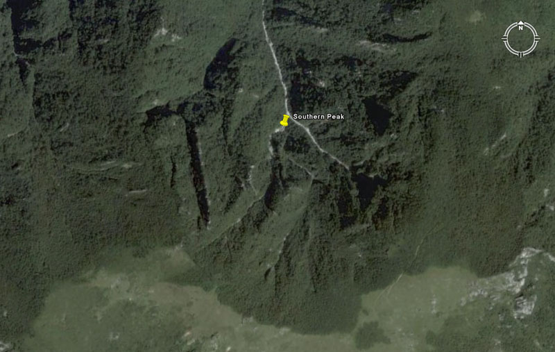
What appears to be the highest peak of the mountain range (over 8200') sits at a perfect 180° (due South) from the centre of the top platform of the pyramid. By pointing a manual theodolite or alidade sighting rule onto this single outer marker target alone, then setting a 360-degree calibrated disc to represent due South, precise degree angles to all other targets around the entire horizon could be fixed with absolute accuracy from the top of the pyramid.
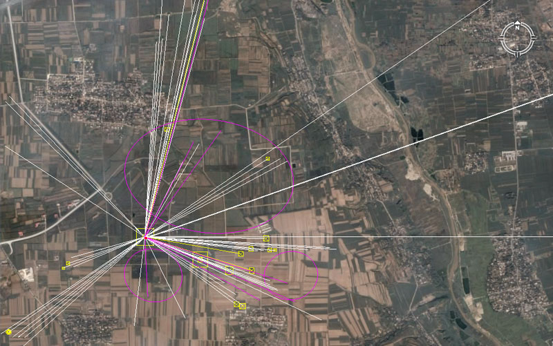
Vectors fan out from the centre platform position of the largest pyramid in this complex at XI'an to outlying pyramids and mound positions. The larger pyramids of the region are shown as yellow boxes and some attempt is made herein to decipher the intended side lengths for a few pyramids, in lieu of any measurements being officially supplied by the Chinese authorities to the worldwide research community. Each line seen above runs at a coded length and degree angle that is fully decipherable within the known values used by the ancient Caucasian cousin nations in all of their integrated and shared Weights, Measures and Volume standards since remote antiquity.
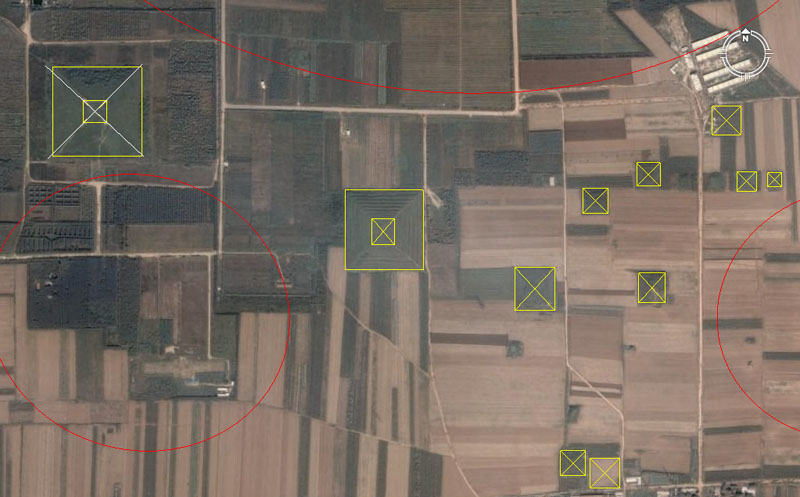
The yellow boxes contain sample pyramids or substantial remnants thereof. Between some of the boxes are yet other smaller pyramids. By using the excellent Google Earth calibration tools available, one is able to hover a few hundred feet above what remains of each structure, many of which are in a bad state of repair or have been severely damaged in the past 30-years or so. Although, in most cases, we can not reliably see the corner positions to accurately determine the size, it's still possible to measure the coded distances and angles out to these pyramids from the centre of the main pyramid. Red ovals in the above picture indicate where clusters of small pyramids clearly were in evidence in the 1976 spy satellite photo, but don't exist any more.
A very noticeable attribute of the XI'an pyramids is that they all seem to have been positioned to relate to the primary points of the compass. The sides, therefore, run true North to South or true East to West. By consequence, pyramid groupings in other areas of China are offset at a coded degree angle and a complex in a separate region will generally have all related structures offset at the same degree angles. This then leads to the surrounding farm fields and roads being aligned in accordance with the azimuth angles found on the local pyramids.
An example of this can be found some distance away from the set seen above amidst a separate pyramid complex about 6-miles to the northeast.
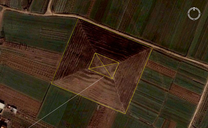
Located exactly 62/3rds miles (35200') northeast of XI'an is this pyramid from a separate complex. Whereas the cluster of pyramids to the southwest sit on the primary points of true North, South, East and West, this one and its nearby partners are offset from North by 22.5-degrees. The sides, therefore, sit on secondary points of the compass of 22.5°, 112.5°, 202.5° & 292.5°. As can be seen, some slumping of the terraces has occurred on the southwestern side. This pyramid is located at Lat: 34.235855, Long: 109.118553.
Note how the fields and roads surrounding this pyramid closely approximate the pyramid's side angles. This attribute in the outlying landscape is duplicated wherever the major pyramid clusters are found within China and probably indicates that the creation of farm fields followed the erection of the pyramid complexes. It would seem that the standard pyramid orientation for a regional cluster established the "Feng-Shui" (Holy Lines or Holy Ways of the Dragon) for the layout of everything else in the immediate vicinity.
Unlike the majority of the pyramids to the southwest, which are mostly square, this one is slightly rectangular. The codes of length and breadth appear to comply to the following:
1 The two long side lengths are 506.25' each and lie on a southeast pointing angle of 112.5°.
The distance is a strong lunar code and a mathematical progression based upon 50.625 (505/8ths) will deliver up highly useful lunar cycle values. For example, the 354.375-day lunar year is 7-periods of 50.625-days.
The angle is the same as that which is coded into the positions of Stonehenge of Southern England in relation to a newly found standing stone circle called Bluestonehenge, which sits away from Stonehenge's centre at 112.5-degrees.
2. The two shorter sides appear to be 453.6' and lie on a northeast pointing angle of 22.5°.
The distance is a strong navigational code and duplicates the vertical height of the Great Pyramid from the desert floor to the top of its flat-floor altar. Although it's long been assumed that the Great Pyramid was built with a pointed top, it's never been observed to have one in all recorded history, spanning thousands of years. The evidence would suggest that it was built as a truncated pyramid, like those in China and that its height represented a fraction of the Earth's equatorial circumference.
The 453.6 value is very strong navigational coding. The Great Pyramid is 756' long, which is 9072" (4536" X 2). Under the Great Pyramid's geodetic system, the equatorial size of the Earth was set to 24883.2 Greek miles of 5250' each. Therefore one degree of arc was 362880', of which 4536' represented 1/80th part.
BABYLONIAN SINGLE STANDARD.
1 Talent………453600
grains, equals:
60 Mina…….. @ 7560 grains, or:
3600 Shekel… @ 126 grains.
BABYLONIAN DOUBLE STANDARD.
1 Talent………907200
grains, equals:
60 Mina…….. @ 15120 grains, or:
3600 Shekel….@ 252 grains.
The degree angle code is again duplicated in the Southern English landscape, where the angle from the Bluestonhenge walkway marker to the prominent southern marker of Woodhenge is 22.5°. The distance and angle codes repeat all over the world, at coded-position complexes from the pyramids of Egypt to Avebury Henge in England to the Nazca plains in Peru to Easter Island, etc.
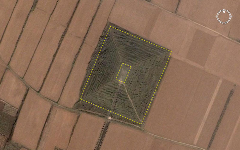
Here's yet another of these offset pyramids, this one being situated southwest of the one previously shown. Again, by careful observation one can reliably deduce that the intended angle of orientation was 22.5° off true North. A meandering road and some irregular vegetation to the southwest and northwest sides tend to distort the initial view, but the general angles of the terraces (despite some slumping on the southwestern side) and the surrounding fields supports a 22.5° off-North orientation.
This pyramid appears to be 540' (lunar and navigational value) X 453.6' (navigation). Another very close proximity value that could be considered for the long sides is 544.32' (5448/25ths equatorial size of the Earth). These values are found encoded into the dimensions of many sites worldwide, including at Avebury Henge in England and amidst the Nazca lines of Peru (both of which were "open air universities" for teaching astronomy and, especially, navigation to trainee navigators).